
Exploring Lake Coleridge
- Apr 30, 2025
- 3 min read
Thursday 24 April
A big day in the wide open spaces around Lake Coleridge and its village and power station. 3*C and a frost made this one of our coldest days yet… we decided to layer up and go for a walk at the Lake.


Set off on foot then realised the walk we had in mind started 6-7km away so headed back to collect the Pajero… then discovered the direct road was a private one so we took a big loop round to the intake from the lake to the power station pipes. We did try to drive down to the lakeside but had to reverse back up to the carpark rapidly as we realised that the weather had eroded away the track, ending in a 1m drop off!
Lake Coleridge has been formed by nature over millions of years and is not one of the many southern lakes created over the last century by damming rivers to create hydropower. Early Maori called the lake Whakamatau. The area had a plentiful eels and birds and was an important food gathering stop for people crossing the Southern Alps seeking greenstone (pounamu) from the West Coast. The lake was identified in the early 1900s as an ideal feeder for NZ's first hydro power station which was to be based at the Rakaia River almost 170m lower, using gravity to feed the turbines. With the relative proximity to Christchurch, it was also a prime location. There are two breakwaters on the side of the lake and a pole with a warning flag around 20m off shore and you can see the whirlpool created by the water being sucked into the intake - fascinating!


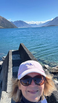


I took a walk along one of the breakwaters and was getting serious St Andrews Pier Walk vibes... where was my red gown?!?
We headed back along the road and found the start of the Lake Hill Track so set out to walk another few kilometres of the Te Araroa trail. It was an easy pathway across private land and was surrounded by stunning views. We walked to a wee bay on the Lake and had a lovely picnic down by the shore.


We took a cheeky excursion out onto the stony promontory and even managed to fly the drone for a few minutes - yay!


Heading back to the car the views continued to amaze - this is a wonderfully unsung area of Aotearoa.


Back at Banjo, Louis took a siesta while I went exploring down to the Rakaia River and back along the Tailrace Track. The cemetery at the outlook over the Rakaia River was quite moving, but the big black marble bird of prey headstone was a bit much! Interesting to see the moa cooking pit which was discovered in the 1950s - many moa bones were excavated there.


The pathway back along the Tailrace (the water flowing to the river from the power station) was quite magical - many of the original settlers here used to throw their compost and trimmings out over the fence so a huge variety of fruiting and flowering shrubs now grow wild along the path, and as the autumn colours begin to shine through, the walk was just stunning.
Back at the power station I had a peep in through an open doorway and a wander around the outside of this early 20th century engineering marvel - build in 1911-1914 on glacial moraine, it was thought to be an impossible task, but around 400 workers pulled it off at great risk to life & limb, living in tented communities in this remote and somewhat hostile, freezing environment.

Dinner at Banjo (venison meatballs made by hand) then we settled in for more Traitors until the laptop power ran out! Snuggled up with a metre long hottie bottle and slept well in the countryside silence.


Comments